Trip Date: December 11, 2011
Participants: Alexis Guigue, Steve Bell-Irving, David Haslam, Rob Kay, Travis McClinchey, Andrzej Jarzabek, Ed Zenger, Geoff Zenger (organizer)
Difficulty: 3. Easy rock scrambling, slopes to 30-35 degrees, dense forest low down
Elevation Gain: 920m
Report: My first ski trip on the BCMC schedule to actually run this season! The trip began by meeting up at the Mt. Currie Coffee Company in Pemberton just before 8am, making all of the necessary introductions, and setting off to the weather station pullout right at Cayoosh Pass. We set off from the cars at about 9:30, with 7 of us on skis, and 1 on snowshoes.
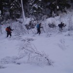
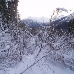
The first 10 minutes or so of the trip were easy going, and then we hit the logging road. When I went up towards Mt. Chief Pascall in February 2011, the logging road was completely covered, and we took it to the clearcut a couple hundred metres to the east, which was then easily descended. This time, however, with no appreciable snowfall in 2 weeks, the logging road was a brutal alder bash, which we had to take all the way to the east side of the clearcut as from below the clearcut did not appear to be skiable.
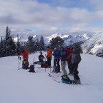
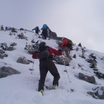
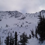
From the east end of the clearcut, we had little difficulty ascending the forest, slowly traversing around to the east side of the ridge to avoid the bluffs high up, and soon entered the gentle basin at treeline to the north west of the summit. From here, it was an easy skin up to the west ridge of Chief Pascall. After a quick snack break (and to give our valiant snowshoer a chance to catch his breath!) we skinned up the narrowing ridge (with some difficulty in places due to the low snow level) up to the top of the large gully descending from the summit (~100m below the summit) and left our skis behind to scramble the remainder of the ridge.
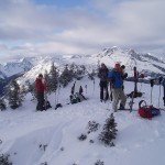
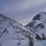
The final ridge was an easy scramble, although the going was slow with many of the rocks covered with only a few inches of snow and ice. We all reached the summit around 1:30 and took our time to eat, drink, and gaze at the north/east faces of Joffre.
Leaving the summit, we made quick time down to our skis (despite one of my legs post-holing into a gap between two boulders approximately 3m deep!), and began our descent by skiing the top couple hundred metres of the wide snowslope labelled “Equinox” on Baldwin’s Duffey Lake map. With a bit of foresight, we could have left a vehicle at the Marriot basin trailhead and had a fall line descent most of the way down, but alas, that hadn’t crossed any of our minds and we quickly had to begin our traverse to the west in order to reach our vehicles. Around treeline we found some fantastic powder, but the traversing was not steep enough for our snowboarder to properly ride and I think he found much of the descent quite tedious.
Back down at the clearcut, we started to bash through the alder on the logging road, but Alexis smartly decided to take a peek through the bushes to see if he could scout a clear line through the clearcut, and as it turned out, he could! Although not phenomenal by any means, we had a nice run through the clearcut back down to the logging road, and from there it was a quick ski down through the trees to the vehicles, where we arrived around 4:30pm. The route taken is definitely much more suitable for skiing than snowboarding, and so I learned something for next time. Nonetheless, everyone made it down before dark, and fun was had by all.
Verdict: 2/3.
Note: I forgot my camera at home for this trip, and so all photos were taken by my dad on his camera